Over the past twenty-four years I have noticed a variety of unusual lithic constructions in Nashoba, Massachusetts. A particular structure that keeps turning up is a flat-topped table-like structure, either round or rectangular. I call these structures "altars", although it is unclear what exactly they were intended for. So far I have recorded and investigated six. There are two varieties: round and rectangular. These are found as follows: 2 on Oak Hill, 1 at Lake Nagog, 1 at Nagog Hill, 1 at Black Pond, and 1 at Half Moon Meadow Brook.
The following is a review of the structures and their environment, a discussion on possible uses and builders of these constructions, and my conclusions to date.
Sites:
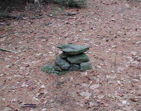
1 & 2. Oak Hill, Littleton. There are two of these structures on Oak Hill, one round and the other rectangular (since removed). They are located in a secluded grove on a plateau at an elevation of 180 feet above the surrounding countryside. The grove is irregular in shape, but encompasses about a half acre in size. It was cleared and maintained by parties unknown. Most of the trees under 4 inches in diameter had been cut down and removed along with the undergrowth. The forest floor had been picked clean of fallen wood and debris. The large trees were left, but had been pruned of branches up to about 8 to 10 feet by the apparent expedient of breaking them off. All the brush and cuttings had been dragged about 12 feet beyond the edge of the grove and left in piles around the perimeter. When I first noticed the grove in 1989 it did not appear to have had any upkeep for some time, nor has it since.
The first of the two structures is round in shape. It is located in the middle of a roughly circler area in the grove amongst some mature white pines. It is constructed of stones placed on what is either exposed bedrock or a protruding boulder. It is 16 inches high with a flat, roughly triangular shaped rock resembling a large arrowhead topping it off. This rock is approximately 19 inches in diameter. The supporting structure of stones is an oblong shape. The axis of the oblong is the same as the axis of the arrowhead-shaped stone top: 356 degrees true, (N04W). Also, were the structure to predate the trees, it would give a fine panoramic view clockwise from the northwest to the south. Its situation, however, gives the impression it is the central focus point of a circular area.
Oak Hill
.
.
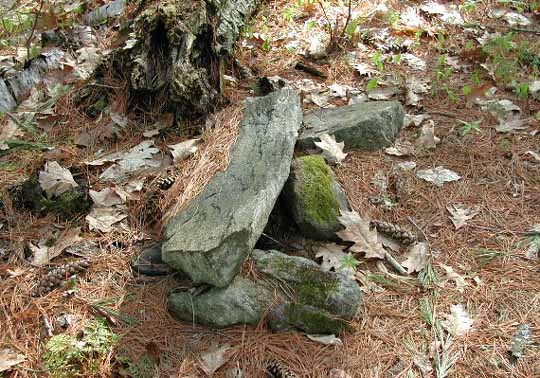
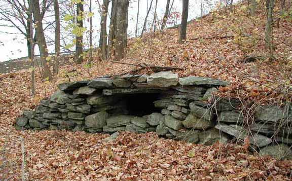
The second structure was located about 60 feet southwest of the first,
in what is now a more densely forested part of the grove. This structure
was the largest of the six I have recorded. It was built of two side-by-side
pillars of piled stones, with a rectangular slab resting on top.
The entire construction was about 2½ feet high. It was set
in a slight depression next to a rock pile. The rock pile is about
12 feet in diameter, and is interesting if for nothing else then that it
is the only rock pile I know of on Oak Hill.
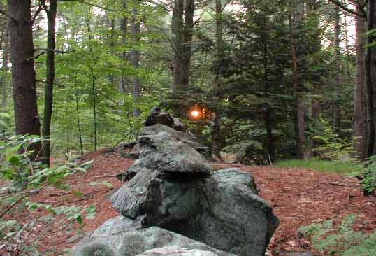
The rectangular slab was oriented lengthwise on a northeast-southwest axis (N38E magnetic) and faced the rising sun at Midwinter solstice. In fact, were the trees less dense it would be possible to see the sun rising over Newtown Hill. As an experiment, the following photo was taken at 7:25 a.m. several days after the 2001 winter solstice. The sun is seen through the trees as its first light flashed over Newtown Hill.
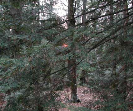
Midwinter Sunrise at Oak Hill
.
.
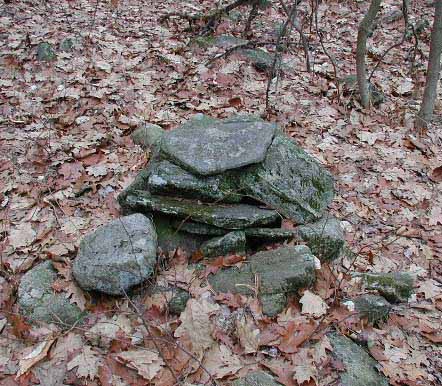
In 1995 a major snowstorm destroyed a number of beautiful old trees
in the area. Here in the grove, a mature white pine fell nearly on
top of the structure, but did not damage it. The following summer,
however, the structure was no longer there. I was unable to even
discover what had become of the stones. It is not a rocky area, and
wherever they went, it must have been quite some ways. All that is
left are two partially buried stones that made up the base of the stone
pillars. Although it is unknown who removed it or why, the disappearance
of the structure is suggestive that there may still be some sort of activity
and interest in the site.
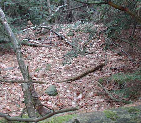
Site of Structure with Visible Foundation Stone
.
.
Based on the condition of the brush piles and the appearance of the
stumps, it would appear that the last maintenance of the grove occurred
in the early 1980s or before. The structures would be at least that
old, and most likely older. My sense is that the grove and the structures
are part of the same creative effort whatever that was meant to be.
If these two structures were meant as places of viewing the horizon or like the larger of the two the Midwinter sunrise, this would require open sightlines. The last time this area was sufficiently clear of trees was 60 to 70 years ago. The current woods began to regrow only after the water tower was constructed in the 1920s.
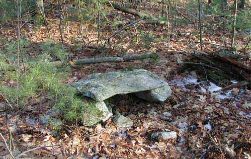
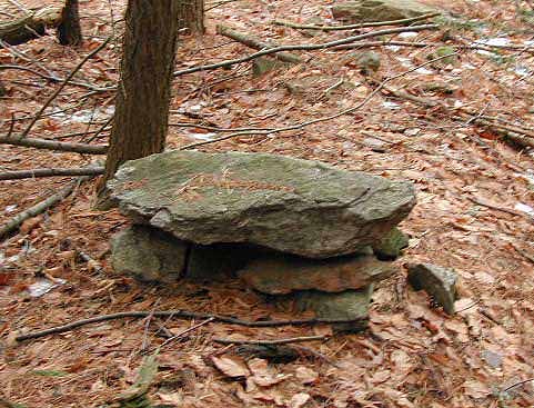
3. Lake Nagog, Acton. Within several hundred yards of Lake Nagog on the eastern slopes of Crow Hill is another stone construction. This is a low stone structure, raised on two pedestals of rock, topped with a rectangular flat slab 3 feet long and 1½ feet wide. It is only 15 inches high, and resembles a low table. It is situated - awkwardly I thought - at the base of a small hill. The top slab is inclined slightly to match the incline of the slope it is on. The long axis of the top slab is north-south, only 5 degrees from exact celestial north, and faces east. (Azimuth 355 degrees true, N05W)
Lake Nagog
.
.
A number of 3 to 4 inch diameter trees were cut and laid lengthwise
upon low supporting poles to the immediate right side of the structure
making a low 5 foot by 8 foot platform, now very much rotted. One
of the poles was leaning up against the structure when I first found it.
Based on the decomposition of the wood, it would appear they were cut and
arranged between 1980 and 1985. Because of the wood leaning on the
structure, it would indicate that it has not been maintained or used since
then.
This structure is built on land that was farmed for hundreds of years. It is an area rich in cellar holes and old foundations, and was under Colonial cultivation since before 1675. There are no other stone constructions or even piles of stone in this particular field, having been cleared long ago. It would be odd indeed if this structure existed while this was grazed or plowed. It seems unlikely that the structure pre-dates the return of this field to woodland. The regrowth of trees does not appear to be older than 60 years or so.
There are some interesting stone rows of non-typical construction in the vicinity. They are made of cobble-sized stones and have a rounded construction, rather than the more typical squared cross-section. They appear to have originally been freestanding rows that were later incorporated into, and joined with, the network of Colonial walls in the area. The rows run within several degrees of either due east-west or north-south. The structure is 70 feet from one such row, but appears to be of less antiquity.
Although the structure faces east, it does not seem to align with anything such as a specific sunrise or a significant horizon marker. The denseness of the woods does not allow for accurate observations, however.
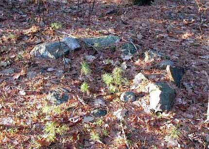
4. Nagog Hill, Acton. About three tenths of a mile from the previous structure is a similar construction. It is about the same size and style: 2½ feet long, 1 foot wide, and 10 inches tall. The flat top-slab appears to have slipped off its supporting stones. The structure is oriented lengthwise on a east-west axis, (azimuth 84 degrees true, N84W), and faces due celestial north. Its orientation is only 6 degrees from true.
Nagog Hill
.
.
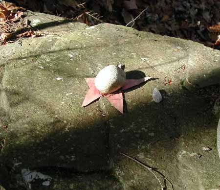
Partially hidden underneath the structure was an odd item: an artists
conch fungus (ganoderma applanatum), such as are commonly found growing
on rotted trees. It had been broken off, and four small sticks stuck
in a rectangular pattern into its underside, like legs. I placed
this upon a rock and photographed it, and then returned it. I have
no idea what if any significance it may have. It appeared to have
fallen off the top-slab and been partially covered by it when the slab
came off its supporting stones.
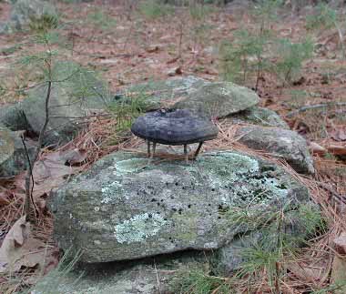
Oddity ~ Nagog Hill
.
.
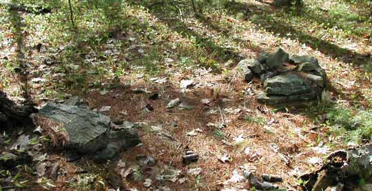
This area is another such place that was in long-term cultivation until
quite recently. The structure is situated under the eaves of a beautiful
stand of white pines. Four feet directly behind it in the south is
a small c-shaped stone ring, 2 feet in diameter. The opening in the
"c" faces the altar-like structure and is on the same N06W facing line
as follows:

Position of Structures
.
.
The c-shaped stone ring resembles a campfire pit, the placement of
which suggests that the altar-like structure was a table used for camping.
However, there is a nearby structure that resembles a prayer seat, which
suggests possible antiquity or a Native American context to the site.
It faces due east with an orientation of azimuth 87 degrees true (N87E),
a deviation of only 3 degrees. It is also possible it is only the
remains of a large campfire ring, and that this was once a Boy Scout camping
area or something similar. There is also a 5 foot stone ring nearby,
suggesting camping again, yet awkwardly placed in the slope of a shallow
cutting.
Prayer Seat?
.
.
In support of the idea that there is an antiquity to the site is the
fact that it is several hundred feet from an Indian corn
grinding stone on a rocky hill. But again, I doubt any of the
stone constructions in the pine grove would have survived the extensive
cultivation of the field. Whatever the structures are, I doubt they
predate the regrowth of the forest.
5. Black Pond, Littleton. This structure is situated in an interesting geological zone, being an area formed by the same glacial activity that formed Tophet Chasm at Oak Hill, which is nearby. Here on a ridge overlooking the swamp northeast of Black Pond is a Colonial era lime quarry. It is similar to the one at Estabrook Woods in Concord-Carlisle, though less sinuous. It is a long narrow v-shaped ravine, at its most about 20 feet wide at the top, 15 feet deep, and 110+ feet in length. At first inspection, it appears to be the result of some violent upheaval of nature, rather than the work of man. There are several smaller lime quarrying ravines tailing off from its ends in either direction, following the seam.
At the north end of the largest quarrying ravine is a low row of stones that proceeds from the mouth of the ravine about 45 feet to the mouth of a smaller cut. It is a most unusual row, being mostly made of large oblong shaped stones laid side by side, rather than lengthwise, and with no stones piled on top in a second or third tier like most rows. In places it appears as an earthen berm about 4 feet wide and 6 to 10 inches tall. Built on the berm portion, on an inclusion of bedrock, is a stone structure formed by a hefty flat slab placed on several smaller stones. The structure is 15 inches wide, 33 inches long, and about 13 inches high. The slab top is the largest by weight of the six investigated.
Black Pond
.
.
The long axis of the top slab runs azimuth 331 degrees true, (N29W).
This being so, it faces both the estimated midsummer solstice sunrise position
at 61 degrees true (N61E), and the estimated midwinter solstice sunset
position at 241 degrees true (S61W). The top slab is such that it
has a triangular contour to it. The apex of the triangle not only
points towards the midwinter solstice sunset position, but does so by sighting
along the length of the high back-ridge of the quarrying ravine.
The back-ridge of the ravine is a solid bedrock outcrop that was not altered
in quarrying, and thus that portion of the sight line remains as nature
created it. This area, however, is heavily forested at the moment,
and officially confirming these alignments may not be easy or conclusive.
The quarry was owned by the Whitcombs, a prominent Littleton farming family, and was probably operated between 1720 and 1780. Limestone from the quarries was smelted into agricultural lime for the fields. It is unlikely that he row connecting the two quarrying ravines can be older than this. Also, the southern end of the large ravine is the terminus point of a more typical row that joins it at right angles. It is probable the quarrying ravines were incorporated as readymade features in the boundary making and stonewall creating process of the time.
It is hard to determine how old the altar-like structure is. The portion of the berm on which it is built is actually a small section of raised bedrock and not row stones. Therefore it may have been there before the row was created. However, it seems unlikely either the structure or the berm/row would have pre-dated let alone survived the quarrying. If the orientations do indeed mark sunrise and sunset points, the constructions would have had to at least been erected prior to the regrowth of the trees that occurred here about 80 years ago.
The terrain is such that a structure postdating the quarrying era, however, could well have survived. The quarrying area is bedrock, ledge, and cliff, and does not support plow cultivation. It could have been grazed, but due to the ravine and the steep drop-off to the swamp it seems unlikely. Typically, otherwise unusable land on high ground was used as a wood lot so the trees could be dragged downhill to the farmhouse. The quarrying ravine is in such a situation: high rocky ground behind a farmhouse.
There are a number of interesting constructions in the local vicinity, including two stone chambers, as well as a stone shelter on the banks of Black Pond. In the immediate vicinity is an enigmatic stone row. It aligns close to both the estimated summer solstice sunrise position at azimuth 54 degrees true (N54E), and the estimated winter solstice sunset position at 234 degrees true (S54W). The alignment is made at the point the row runs the length of a large white-quartz-bearing bedrock mound. The stones on the mound portion are very large, odd shaped, and oddly placed, unlike any other stone row construction I have seen.
On either end of the bedrock mound this construction appears to have had typical colonial-style rows attached to it at some time. The row and bedrock mound are such that it gives an excellent sighting line when standing at either end for viewing either the midsummer sunrise or the midwinter sunset. (As mentioned previously, this area is heavily forested at the moment, and officially confirming these alignments may not be easy or conclusive.) There is also what may possibly be a prayer seat situated in one of the smaller quarrying ravines, which if so, argues for some sort of post-quarrying lithic activity.
I walked the area with a resident who had known the place as a boy during the 1980s, but he had no clear recollection of the altar structure, nor of the prayer seat for that matter. If it is new, it would have thus been constructed during the last 15 years. However, he could not definitely say it had not been there either. His testimony, unfortunately, neither ruled out or confirmed its earlier presence.
6. Half Moon Meadow Brook, Boxborough. The sixth structure is to be found in a rock-strewn marshy area in Boxborough. This is a carefully constructed conical pile of stones with a small flat top stone, built upon a small hump of bedrock. The structure is about 20 inches tall, with a diameter of approximately 18 inches at the top.
Half Moon Meadow Brook
.
.
This conical construction is at the terminus point of a stone row.
Like the structure at Black Pond, this row is more like a line of stones.
The stone line connects the structure back to a ridge of exposed bedrock,
thence across the marsh and up a hill to the viewing platform of a Midwinter
solstice sunrise alignment. See Half
Moon Meadow for a full report on the sunrise alignment and associated
lithic features.
The swampy area is strewn with rocks and ridges. There are also a number of enigmatic stone constructions such as a dolmen, circles of stone, stone pile structures, and at least one standing stone. It would seem the purpose of the stone row was to connect the viewing platform at the sunrise location on the hill to the lithic structures in the swamp. That the altar-like structure is at the terminus point of the row makes it seem even more significant.
Being conical shaped, the structure does not seem to have any particular orientation. However, the flat rock on top is shaped like a chevron and points azimuth 46 degrees true (N46E). I have not found anything of significance in this orientation however. The stone row of which it is a terminus point runs azimuth 354 degrees true (N06W).
This marshy area is not suitable for cultivation, and it does not appear that it has ever been cleared of its fieldstone. Lithic features in this section would not have been threatened by field clearing operations. The profusion of field stone would probably have precluded grazing as well because of the danger of the animals breaking their ankles among the jumble of stones. This allows the possibility that any lithic constructions of an earlier time would have had opportunity to survive to the present day.
The row that terminates in the structure - being more like a line of stones - is not similar to the typical stone rows in the area. It appears more concerned with connecting than with enclosing. This suggests to me more of a spirit approach behind its construction than a pragmatic one. My sense is that it may be of native construction of an unknown date. I would group the row with the structure and other lithic features as a whole: a complex created of the same effort and of the same time.
Discussion:
There are a number of possible explanations behind these structures: recreational stone piling and balancing, cairns and markers, field clearing piles, neo-pagans, pre-contact and post-contact Native Americans, camping, and follies & hoaxers. I am excluding Nature because these structures appear to be of human origin.
Stone Piling & Balancing. It seems to be a recreational activity to make a pile of rocks balance one upon the other. I often see these balanced pillars at the seashore or along rivers. The people Ive seen making them have all appeared to be on vacation and enjoying the challenge of balancing the stones. In fact, some consider it an art. None of these structures in Nashoba are balanced, or are balanced pillars. They are sturdy constructions that have weathered years.
Cairns & Markers. Another stone-piling construction are cairns. These are conical piles typically seen along hiking trails as way-markers. Hikers add stones to them as they go along. The Half Moon Meadow Brook structure is the only one that has any resemblance to a cairn. But, it is in a swampy area with no discernable trail. Its construction is as a finished product, not as something that has been built up with random donations of stones over time. It certainly does have the appearance of a marker of some sort, however. Whatever else it may be, it appears to mark the area and draw attention to it. The other five structures while certainly drawing attention, do not appear like marker piles.
Field Clearing Piles. Generally the stone rows are from clearing the field, and the piles are from plowing it. The piles are typically low wide mounds of jumbled rock, usually about 10 feet or more in diameter. None of the six structures resemble field clearing piles in any way. Indeed, rather than the result of clearing, they look like items that would need to be cleared. The Black Pond, Oak Hill, and Half Moon Meadow Brook structures are in areas that do not appear to have ever been cleared of field stone, let alone plowed.
Neo-Pagans. From at least 1980 onwards there has been a neo-pagan community in the Nashoba area. John Mitchell writes of Nashoba in Trespassing: Neo-pagans have set up a celestial tracking stage here wherein they worship the rising or setting of the sun, moon, and stars. Once I even found a stone circle in the area, a sort of miniature Stonehenge.
I use Neo-Pagan to denote the loosely organized pagan religious revival movement that arose in England in the 1940s and was imported to the US in 1964. This movement follows the spirit of pre-christian Northern European religious practices. Beyond this specific movement, there must certainly have been others previous to it that expressed a European paganism in the New World. Thomas Morton, who in 1626 founded Ma-ra-mont (Merrymount) in what is now Quincy and erected a May Pole there, comes to mind.
In Neo-Paganism, altars are commonly used. Being a nature religion, it would not be unexpected that its practitioners would erect an altar in some outdoor place. From my research I have found that there are two altar styles used in Neo-Paganism. The first is a rectangular structure. These never face a celestial event, but rather a cardinal direction, either east or north, and on a magnetic axis more often than a polar one. The second style is a round or square altar set in the center of the proceedings. The rectangular structures at Oak Hill and Nagog fit the first style, facing either east and north. The smaller round structure at Oak Hill is in the center of a circular area and fits the second style. The position of the rectangular structure at Nagog Hill is such that it faces a cardinal direction, and several feet behind it is a c-shaped stone ring/campfire in a central area. The combining of the two with the ring/campfire serving as the central point and the rectangular altar coordinated to face a cardinal direction, in this case north is a classic positioning of a neo-pagan altar and circular central area. And, where the two are combined, the central structure of the circular area typically houses a fire for dancing around. The structures at Black Pond and Half Moon Meadow Brook do not seem to fit in with either style, and would not facilitate a formal neo-pagan style use in any event.
Altar Stone (left) & Center Ring (right)
.
.
Neo-pagan sites are meant to be special places in nature that are aligned
to the four quarters, not viewing stations of celestial events.
Due to land use and such clues the sites themselves provide, the Oak Hill and Nagog structures are not likely to have been there earlier than the 1950s. They would seem to have been created sometime in the 1970s or 1980s all of which fits in with a Neo-Pagan scenario. I do have to add that I have never seen anyone at these sites, nor have I ever found anything there that could hint of religious use. In fact, these sites do not seem to have been maintained since around 1985. The removal of the large rectangular altar on Oak Hill does point to activity, but by whom is unknown.
An example of a Neo-Pagan altar and offering is the one I came across
on Mill Brook in Williamsburg in 2001.
Neo-Pagan Offering
.
.
Native Americans, pre-contact and post-contact. It is
routine to hear from official archeological sources that New Englands
Indians did not work with stone. Due to this stance, there are really
no officially sanctioned lithic structures of New England Indian origin
to use for comparisons. Thus I have turned to James Mavor and Byron
Dix for a second opinion. Their book Manitou is a presentation
of their theory that the Indians native to this area did indeed create
lithic structures. Among other things, Mavor and Dix theorize that
certain stone rows are of native construction. Particularly rows
that connect a feature of the landscape with another, like water and a
hilltop. These can also connect a constructed lithic feature
with a natural one like a ridge or a boulder.
Why this is interesting is that both the Black Pond and Half Moon Meadow Brook structures are found as part of connecting style rows. The Black Pond structure is built on a row that connects the mouth of one quarrying ravine with the mouth of a second one. The Half Moon Meadow Brook structure is the terminus point of a row that connects several manmade and natural features over the course of its wandering path. This connecting feature suggests - if Mavor and Dix are correct - that these are indicators of Native American construction and origin.
Mavor and Dix also claim that this construction style and culture existed from pre-contact times up until fairly recent modern times. They felt that local Indians were still working with stone in the landscape in the traditional way. Of the six structures under consideration, only Black Pond and Half Moon Meadow Brook have this connected-to-the-landscape feature.
Camping. It is possible that some of these low bench-style structures may well have been constructed as tables for camping purposes. The wood next to the one at Lake Nagog is suggestive of firewood. I did not find any indication of camping or campfires in the vicinity though. It did not appear to have been used since the mid 1980s, so there may simply be no trace of a camping fire left. Considering the effort to create the table, it is surprising that a campfire ring was not constructed. I would think the campfire ring would be the more important of the two. Also, it is situated at the bottom slope of a small hill, which would be a poor place to be camping if it ever rained. There is no place for a tent or sleeping bag, and the ground is inclined and rocky. I tend not to believe it was constructed as a camp site.
At the other Nagog site, the evidence for camping is stronger: the low table is four feet from what could well be a campfire ring. It is on a slightly raised area that would drain well in the rain, and there are plenty of smooth flat places to pitch a tent or roll out a sleeping bag. The ground is springy and soft with pine needles. The adjacent structure that resembles a prayer seat could also be seen as a large half-circle fire ring. Prayer seats are known to face either celestial events such as solstice and equinox sunrises and sunsets, or towards the sweep of the Big Dipper in the North. This structure faces true east, which may imply significance, but most likely not a Native American one. The place has the look and feel of a well situated camp site.
The four other altar-structures investigated do not seem to bear any relationship to camping or campsites.
Follies & Hoaxers. It has to be considered too that sometimes people do things for fun and sometimes to deceive. It is possible that these structures have no meaning or purpose and were simply made for the fun of it, such as boys often do. Or, they might be hoaxes. I tend to doubt that Half Moon Meadow Brook is either a hoax or a folly, nor do I think the Nagog Hill "table" was constructed to deceive. The Oak Hill structures may well be follies or hoaxes, being on heavily trafficked conservation land as they are. The Black Pond structure is adjacent to a housing development, and I am told that the quarrying ravines are a favorite play area for the boys in the neighborhood. Heavy though the top slab is, the structure is not beyond the abilities of a group of boys to construct. As for the Lake Nagog structure, I have no sense one way or the other regarding the possibility of a folly or a hoax.
Conclusions:
There seem to be two styles of structures observed: rectangular and round. The rectangular ones have an orientation to a cardinal direction (Nagog Pond and Nagog Hill), or an orientation to a celestial event (Oak Hill Midwinter sunrise). Of the round ones, there are also two styles. The first is the Oak Hill style: oriented as a central focus of a circler area. The second is in association with a row that connects features of the landscape (Black Pond and Half Moon Meadow Brook). This second style does not always have a recognizable orientation, rather it is defined as well by being a terminus point, or a part of, a connection row.
My thoughts on the origin and use of these structures are as follows:
Oak Hill. I would suggest that the Oak Hill structures were made by neo-pagans and are altars. I do not believe they have any antiquity. The amount of work done to create the grove suggests a religious or spiritual effort. The timeframe fits with the revival, and the style of construction is of the kind one would expect from people of a Western heritage in general, and neo-pagans specifically. That the top stone of the round structure points celestial north is intriguing, and again suggests neo-pagans because of their habit of aligning religious structures to cardinal points. That the alignment is off by -4 degrees is, I believe, significant and will be explained further in the discussion on the Nagog structures. The now removed rectangular structure is more difficult to ascribe an alignment, if any, due to the fact that all that is left are two foundation stones. In any event, these are (and were) impressive constructions that imply a pagan-style spiritual impulse at work.
Lake Nagog. This is probably another neo-pagan construction, and if so, it too is an altar. The timeframe and style are a fit. It has been carefully aligned to face the cardinal direction of east, and not a celestial event. That it has been aligned from true north rather than magnetic north, indicates - or so I believe - an unusual level of attention to its construction by neo-pagans, rather than a Native American origin.
Both this site and the Oak Hill one appear to be contemporary. If it not built by neo-pagans, I have no clear theory of who constructed it or why. I do not believe it has any antiquity, and if it is by any way of modern Native American construction, it suggests a borrowing of European cultural motifs.
Nagog Hill. In theory this looks good as a neo-pagan altar. As with Lake Nagog and Oak Hill, timeframe, style, and lack of antiquity point to this. The relationship between the central stone structure and the altar is a classic of modern neo-pagan style. It is interesting to note that it has been aligned from true north rather than magnetic north, just like the previous one. It is perhaps significant that both structures are slightly misaligned from true north by approximately -5 degrees. This suggests not only that they were made by the same person, but also that the same compass was used: a compass that read incorrectly by -5 degrees. Note too that the round structure on Oak Hill is also misaligned from true north by approximately -5 degrees.
The similarities of style and age, the geographic closeness, the exact same misalignment, all suggest the same individual origin of the Nagog structures, and possibly the Oak Hill structures. The styles and orientations certainly point towards neo-pagans. Indeed, on paper Nagog Hill appears to be a classic of neo-pagan style and construction - yet in person it has all the look and feel of a campsite. I am unable to come to a comfortable conclusion one way or the other. Perhaps there are layers of things going on at the site.
To make things more confusing, the unusual rows at Lake Nagog and the prayer seat at Nagog Hill if it is a prayer seat are also misaligned from true by approximately 5 degrees, same as the other structures. I would not consider either the rows or a prayer seat to be connected to or contemporary with these Nagog structures as I understand them. Yet, the same misalignment is there.
Black Pond. This is one of the more puzzling structures, with no clear answers. Although it has the rectangular neo-pagan style of construction, I would rule this out as it does not align to a cardinal point, nor is it situated such that it can be gathered around or gathered behind.
There is a possibility it is of native construction, but if so it would date from after the quarrying in the late 1780s. The attention given to the alignments to the midsummer sunrise and midwinter sunset both in the structure and the nearby row do suggest a native origin. So too does the fact that it is located on an unusual row that connects features of the landscape, which is considered by Mavor & Dix to be a native motif. That the features connected are quarrying ravines may not necessarily rule them out, especially since Mavor & Dix felt that the local Indians were still working with stone in the traditional way up until fairly recently. Also, these quarries do not in any way resemble quarries, but rather appear the result of some natural upheaval.
Also, there is no reason the oddly constructed stone row that marks the midsummer sunrise and midwinter sunset as it crosses over the bedrock mound can not pre-date the quarrying and have antiquity. If this was an important native site, it may be that after the quarrying was over features were rebuilt or added, such as the altar-like structure and the connecting row. In any event, the sightline from the structure to the midwinter sunset runs along the length of the back-ridge of the quarrying ravine. This back ridge was not disturbed by the quarrying, and the altar-like structure may be a rebuilding of a similar structure that was destroyed in quarrying. It is interesting and suggestive that both unusual structures are associated with marking the same celestial event.
On the other hand, this scenario - while attractive - is highly conjectural. It may simply be that the structure is the product of neighborhood kids at play, and the alignments are coincidence.
Half Moon Meadow Brook. I consider this structure to have the most likelihood of Native American origin, and the possibility of some antiquity. First, the structure does not seem situated such for use in a neo-pagan manner. It is of the central altar style, but its location is such that it can not be gathered around in the neo-pagan way. Also, it is not secluded, being easily visible from a road. Most significantly it is at the terminus of a row connecting features of the landscape. It is within sight of a feature identified by Bryon Dix as being a Native American vision quest site. It is in a marsh that has never been cleared of stone, nor plowed, and probably not grazed thus if it were from antiquity, it could have survived. Also, it is connected by a wandering row to a place where the Midwinter and Midsummer solstice sunrises can be viewed.
Strangely enough, the misalignment noted in the Oak Hill and Nagog structures also show up here. The stone row of which the structure is a terminus point is 6 degrees from true north. Whether this is coincidence or has bearing on the overall picture, I do not know. It certainly suggests a relatedness that does not fit with my conclusions that the Oak Hill/Nagog structures and this one are of different origins and eras. I find this consistency of misalignment a mystery worth further investigation.
Without firsthand information it is clearly impossible to satisfactorily
determine who made these structures, when they made them, and why they
made them. If anyone can help identify use and origin, or has a better
interpretation of the data, particularly the consistent misalignment, I
would very much appreciate hearing from them. My email address is
dvb@boudillion.com
* * *
Further Investigations:
On June 19, 2002, I investigated the enigmatic stone row at the Black Pond site to see how closely it aligned to the Midsummer Solstice sunrise. The sun rose at 5:20 a.m., about 2 degrees to the right of the row. The small variation in the sun's rising position between now and the actual Solstice on the 21st is not enough to correct this and make an exact alignment. The alignment is close, but I now have doubts that it is intentional.
Midsummer Sunrise at Black Pond
.
Notes:
When evaluating directional orientations it is important to bear in mind that there is a difference between magnetic north and true celestial north. In Nashoba, the difference is 15 degrees. The Native Americans did not have the magnetic compass, and where oriented are oriented towards celestial events or cardinal points based on the pole star. Magnetic orientations are a sign of post-contact technology in use.
As for the consistent deviation from true north, I used several compasses,
including a surveyors Suunto KB-14, to make sure that it wasnt
my compass that was reading incorrect by 5 degrees.