Rattlesnake Hill, Where Are You?
Looking For, and
Finding, Littleton's Rattlesnake Hill
Littleton Massachusetts
Field Investigations:
April 2005, written 3 May 2005
by Daniel V. Boudillion
|
Introduction
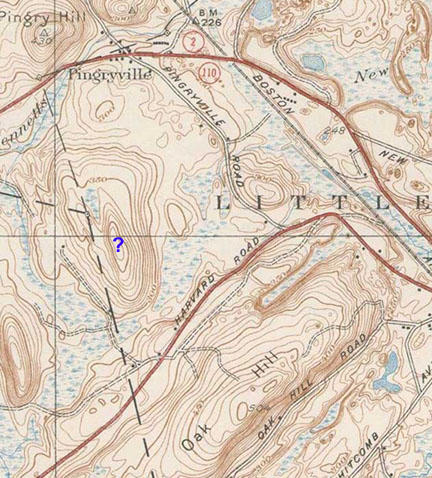
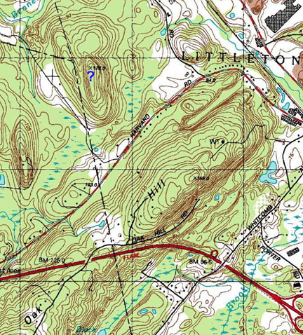
In 1714, Rattlesnake Hill
was a well-known landmark in the newly
formed township of Littleton, Massachusetts. It is often referred to in
deeds to people purchasing land from the Littleton Proprietors.
In the 1896 Proceedings of the Littleton Historical
Society, George A. Sanderson's article Littleton Land Marks in Proprietors' Deeds
notes several such examples. On page 37 of the Proceedings, he mentions
an early Littleton Proprietors
deed into Jacob Powers describing two acres of meadow on the south side of Rattlesnake Hill
and Rattlesnake Hill is also mentioned in a 1719 deed into John
Thatcher.
1
But its location has since been lost.
Looking
for Rattlesnake Hill
Recently I was working on a 1722 deed to
a parcel of land from Samuel Dudley of Littleton to Nathaniel Hammond, also of
Littleton. This parcel referenced several local landmarks: Beaver Brook, Reedy
Meadow Plain, and Rattlesnake Hill. I was aware of Beaver Brook, but since it
runs the length of Littleton I also needed to know where Reedy Meadow and
Rattlesnake Hill were in order to place the parcel on the ground properly.
Thus I contacted the Littleton Historical Society via email.
Belle Choate of the Littleton Historical
Society responded on 4-6-2005 as follows:
"According to Margaret Drury's (local
historian) notes Reedy Meadow is on the southwest side of RR tracks going to
Littleton Depot from Priest's Crossing. On a modern day map it is in the area
bounded by Harwood Avenue/ Rte 495/ RR tracks and the Mill Pond.
"We are still researching Rattlesnake
Hill. Read the reference in the proceedings. It doesn't show on any of the old
maps we have. One board member thought it was the hill in Ayer across from the
old Mill Stream Club (current Bait & Tackle?) between Rte 2A over to Sandy
Pond. Another researcher suggested checking old Groton History."
2
With Reedy Meadow's location thus identified
by the Littleton Historical Society, and with the location of Beaver
Brook well known, the hill that was known in 1722 as Rattlesnake Hill fell into perfect
place with the parcel as defined in the deed from Dudley to Hammond.
What was with all the
Rattlesnakes?
Eastern
Massachusetts was once Rattler Country. When the Puritans arrived in 1620
and set up Plymouth Colony they quickly and displeasurably made acquaintance
with the North American rattlesnake. The rattlesnake was considered
such a scourge and so hated that all rattlesnakes were killed on sight.
Some people even hunted rattlers, and as late as 1840 a women named Prudence
Shedd "became celebrated as a rattlesnake killer, and pelts of these reptiles,
killed by her, adorned the side of her barn in large numbers."
3 Prudence lived on the
easterly side of Snake Hill in Ayer, less then 3 miles from Littleton's
Rattlesnake Hill.
Snake Hill - Ayer Massachusetts
There does not seem to have ever been a bounty on
rattlers such as the Littleton Wolf Bounty of 1749,
4 so it would seem their
extermination was based on a personal and collective hatred of rattlesnakes.
Today's landscape is not the landscape of Colonial
times, which in short order became significantly less wooded then it is now.
Also, there was far less groundcover for snakes to hide in those
times. For one thing, the Algonquin-speaking tribes used to annually burn
the forest undergrowth to such an extent that it was reported of Lancaster (now
Harvard) in 1659 that it was possible for a man to ride on a horse unimpeded
through the forest
7, a feat impossible today.
The Colonial settlers cleared land voraciously for
wood and for pasture, and inherited many such
cleared meadows where the Indians had raised their yearly corn. As time
went on so much land was cleared that there are reports - exaggerated no doubt -
that there was hardly a tree left standing between Littleton and Worcester.
In any event, this situation left the land clear of cover, and this with the
rattler's propensity of sunning itself on flat rocks, left it exposed and easily
spotted.
An example of land clearing resulting in rattlesnake
extermination is as follows: "In 1830, when the wood-choppers were
clearing the hill near Levi S. Brigham's, many rattlesnakes were
killed."
3
Brigham lived in Ayer on the west side of Sandy Pond Road, just south
of the Groton town line, and the hill mentioned is Rocky Hill.
16
The Shedd place and the Brigham place were no more then a mile apart.
This literal war of extermination against the
rattlesnake was ultimately successful after about 250 years, and today there are
supposedly no rattlesnakes in Massachusetts (except in government office).
There are, however, rumors of a small colony of rattlers in the Berkshires on
the Massachusetts-Connecticut line, and more verifiably, an active colony in the
Blue Hills Reservation in Milton (see
Snake Watching
by Tom Palmer). Clearly, the Colonials let us down in the Blue Hills.
|
Springfield Mountain: The Pesky Sarpent bites Timothy
Mirick
 Unsurprisingly,
the first ballad composed in America involves the rattlesnake.
The song Springfield Mountain is the true story of twenty-two
year old Lieutenant Timothy Mirick, a young man who was about to be
married. He was bitten by a rattlesnake in Springfield Mountain,
Massachusetts, on August 7, 1761 and died within three hours of the
attack. His grave can still be seen fourteen miles north of that city. Unsurprisingly,
the first ballad composed in America involves the rattlesnake.
The song Springfield Mountain is the true story of twenty-two
year old Lieutenant Timothy Mirick, a young man who was about to be
married. He was bitten by a rattlesnake in Springfield Mountain,
Massachusetts, on August 7, 1761 and died within three hours of the
attack. His grave can still be seen fourteen miles north of that city.
To read the entire
article,
click
here.
|
Also, a story was related to me several years ago by a
surveyor about rattlesnakes in Littleton. The story went that when the
site containing the stone foundation of the old R. Hazzard or J. Hazzard house
(located across from Black Pond and on the west side of Spectacle Pond Road) was
surveyed in 1997-1998, that live rattlesnakes were found living in the
foundation. In the time honored tradition of Massachusetts, the landowner
"disposed of them" (or possibly relocated them).
9
This singularly important
yet unpleasant discovery was kept quiet.
I would assume that this colony, if it existed, was living on rodents at the
town dump, which used to be next to the foundation before the dump was capped,
and this is what drew them to this particular location.
Hazzard House - Littleton Massachusetts
The local Littleton area Indians also had an
unfavorable opinion of the rattlesnake which is revealed by how they used the
word. The name Maquas, now pronounced "Mohawk" and better known as such,
is an eastern Massachusetts Algonquin dialect word that means "snake."
They used it to describe their ancestral enemies to the west - the hated Iroquois of
New York State. The Mohawk Trail, which runs from New York State to
eastern Massachusetts, was the route the young Iroquois bucks took every spring
from time immemorial in their annual raids on the peaceful Nipmunk and Massachusetts
Indians.
Most of the 1600's era Colonial roads in Massachusetts
Bay Colony were simply the existing Indian trails co-opted for use by the
Puritans, and the Mohawk Trail is no exception. The original path of what
is now Route 2A was essentially the same path as Mohawk Trail. The one
grew into the other, although the two have diverged, and often significantly,
over the years.
The Mohawk Trail runs through Littleton, and indeed,
in 1675, Ahatawance, the chief of the Nashoba Praying Indians of Nashoba Indian
Plantation in Littleton, was "murthered in a secret manner" one spring by the
Maquas [Mohawks] while peacefully fishing for eels at his weir,
13 either on Beaver Brook or on Fort
Pond.
Subsequently, the Nashoba Plantation Indians
constructed a fort, either on the northwest slope of Nagog Hill several rods
north of the spring
12, or
on the peninsula on Fort Pond
7
(hence the name). But they must not have been impressed with their
handiwork, or to few in numbers, because they simply abandoned the area every
spring rather then try to defend themselves against the Mohawk's yearly raids.
In any event, the rattlesnake and where it lived,
lives on today in echoes from Colonial place-names. In Littleton alone
there was Rattlesnake Hill, Rattlesnake Meadow, Little Rattlesnake Meadow, and Snake Road.
Nearby in Ayer there is a Snake Hill, and in Westford there is a Snake Meadow, a Snake Meadow Brook,
and a Snake Meadow Hill. Even after all these years there are still many
place-names in Massachusetts that recall the rattlesnake. There are 34
such rattlesnake place-names still in official use, with 14 occurrences of the
name Rattlesnake Hill, and 6 of the name Snake Hill.
15
For may years these names all served warn and advise
the traveler and local yeoman alike of the presence of rattlers. To the
Colonial mind there was only one snake, the rattler, and snake-named places are
all named for the presence of this hated reptile.
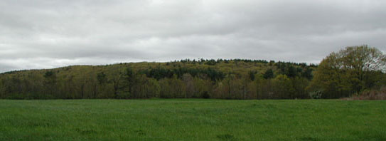
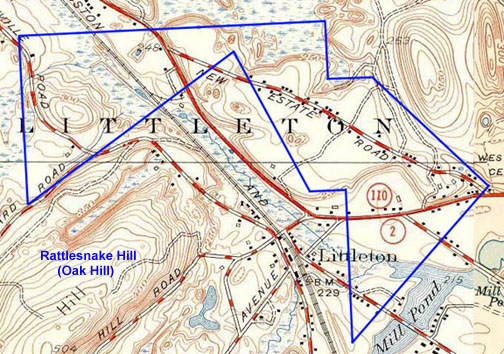
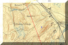
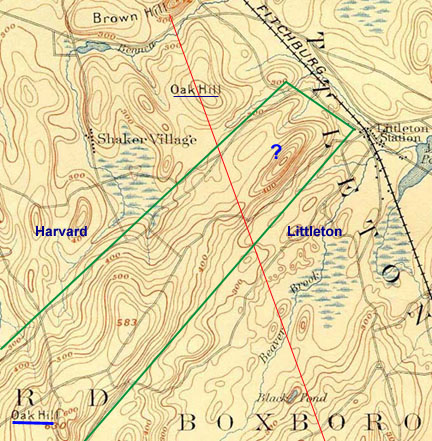
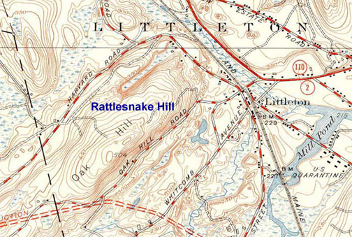
Littleton's Oak Hill is Rattlesnake
Hill
Littleton's
Oak Hill is the "Rattlesnake Hill" of early Colonial times. This is made
clear from two deeds of Littleton land that I researched and plotted as part of
researching the location of Samuel Dudley's 1720 homestead site. The first
of the two deeds was executed February 6, 1722 from
John Parker Junior to Samuel Dudley, both of Littleton. The second deed
was executed July 3, 1722 from the same Samuel Dudley to Nathaniel Hammond,
both of Littleton.
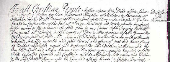
Dudley to Hammond
click to enlarge
The 1722 Parker to Dudley deed reads as follow:
"...a
certain tract of upland land and meadow lying in the Westerly part of
Littleton aforesaid bounded as follows: beginning at a pine tree marked on the
Southerly side of Rattlesnake Hill then running Southerly to a white
oak tree marked then running Southwesterly to a white oak marked and running to a
stake with a heap of stones [or possibly: "to a ____ with ____ on it
and"] running Westerly to Littleton Line then running Northerly on Littleton
Line to walnut tree marked and running Easterly to the first mentioned pine
tree which land and meadow contains by estimation Forty Acres be the same more
or less to have and to hold …" [Middlesex Registry, Book 22, Page 319]
A full transcript of the full deed is below.
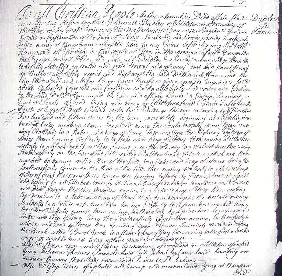
The 1722 Dudley to Hammond deed reads as follows:
"...a
certain tenement tract or tracts of land of lands laying and being in
Littleton aforesaid bounded as follows viz first or biggest tract of lands
with the buildings thereon containing by estimation Two Hundred and Fifteen
Acres be the same more or less beginning at a crotched pine tree upon Reedy
Meadow Plain localled? being the Southwesterly Corner then running Northerly
to a stake and heap of stones then crossing the Highway to a stake and heap of
stones then running Westerly to a stake and heap of stones then running a
little Northwesterly to a black oak tree then running over the Old Way to a
walnut tree then running Southwesterly on the side of the hill called
Rattlesnake Hill to a black oak tree marked so running on the side of the
hill to a stake and heap of stones being the Southwesterly Corner on the side
of the hill then running Northerly to a stake and heap of stones being the
Northwesterly Corner then running Easterly ..." [Middlesex Registry, Book 24,
Page 6] A full transcript of the deed is below.
From these deeds a close approximation
of the parcels can be drawn on a topographical map. One challenge however
is that there are no distances given for any of the boundary line lengths.
So although we can plot the corners and directions, and draw boundary lines, we
do not exactly know how long these lines always are. The best that can be
done is to fit the shape into the topography, with the landmarks in the deed as
a guide. Another clue is the the parcel size, which for example in the
Dudley-to-Hammond deed was "two hundred and fifteen acres more or less."
The "more or less" was very liberal in those days, usually erring on the "more"
side by often up to twenty
percent or more.
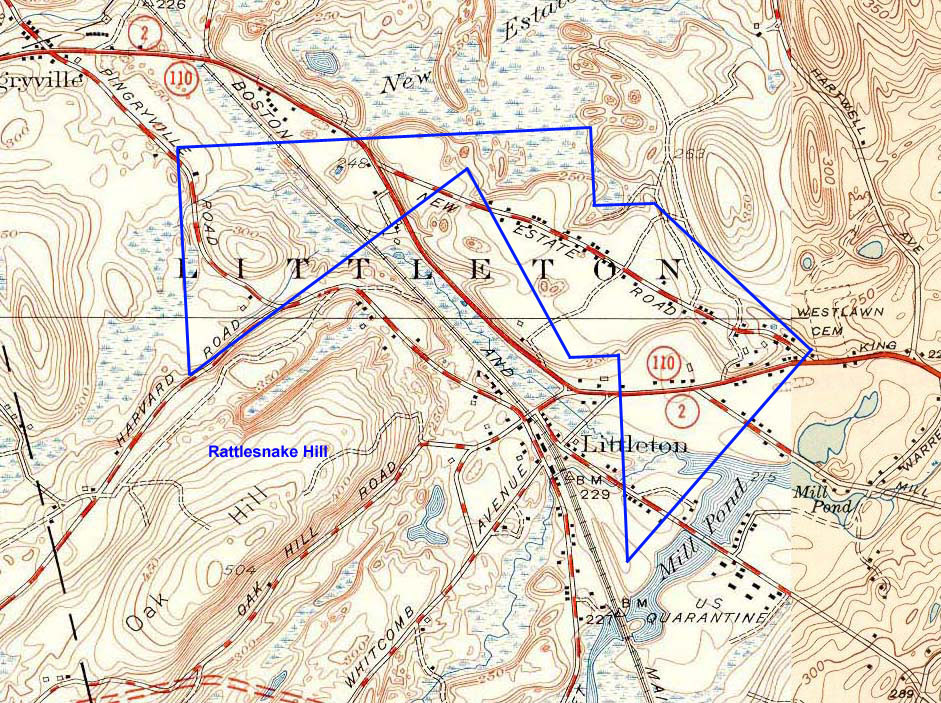
Dudley to Hammond Deed
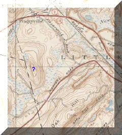
The following topographical map is one such
reconstruction of the Dudley-to-Hammond parcel.
I have used the 1939 USGS Ayer
Quadrangle topographical map for clarity. It is less crowded then the
current 1988 USGS Ayer Quadrangle, and more precise then the 1893 USGS Groton
Quadrangle. I have calculated this parcel as drawn to be about 240 acres.
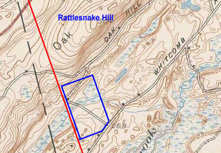
Rattlesnake Hill ~
Dudley-to-Hammond Deed ~
1939 USGS Map
click for large image
Reedy Meadow Plain is a fairly small area and precisely
identified, and thus locates a portion of the parcel on the ground. On the
above map the portion of Reedy Meadow Plain significant to the deed is the
section between the railroad tracks to the west and Mill Pond to the east, where
the southernmost tip of the parcel originates.
As
described in the deed the parcel also crosses Beaver Brook. This crossing
is located where a straight line running northeast from the Reedy Meadow Plain
deed-point intersects the path of Beaver Brook. (Note: on the 1939 topographical map
this crossing is drawn in as crossing Mill Pond. This is because Mill Pond
was created in approximately 1750
7
and prior to this the location was simply the path of Beaver Brook.) This crossing
further and accurately locates this portion of the parcel on the ground.
With these two landmarks established, and deed-points
plotted on them, there is no hill other then Oak Hill that can fit into the
Rattlesnake Hill referenced portion of the deed description. Thus today's Oak Hill is
the Rattlesnake Hill of the 1722 deed and early Colonial Littleton.
Which Side of Rattlesnake Hill?
This being established, there is some initial ambiguity to
which side of the hill the property line is meant to run on. The
deed description "...then running Southwesterly on the side of the hill called
Rattlesnake Hill to a black oak tree marked so running on the side of the hill
to a stake and heap of stones being the Southwesterly Corner on the side of the
hill ..." does not specify which side of the hill the line is on: the north side
of the hill or the south side of the hill. It only specifies that it runs
along a side in a southwesterly direction, and the deed plot can be conceivably drawn
with this line on either side of the hill.
However, we can precisely locate it on the north side
of the hill due to a peculiarity in the northeast part of the Dudley-to-Hammond parcel. The
northeast section of the deed runs as follows: "...crossing
the meadow [easterly] to a stake and heap of stones then bounding upon the
upland running Southerly to a white oak tree then turning Easterly to a pine
tree marked being the Northwesterly Corner ..." This describes the
"L"-shape notch of the northeast corner of the parcel. [See picture
above.] This area is defined by a 1723
mortgage taken out by Dudley on the parcel which fits perfectly into this
L-shape. The description of the property in the mortgage runs as follows:
"...also another piece of land
containing Seventeen Acres and a Half bounded as follows Southerly and Westerly
by land of Mr. Nathaniel Hammond Northerly by land of Josiah Buttrick Easterly
by a Highway that ____ from Josiah Buttrick to the County Road..."
[Middlesex Registry, Book 24, Page 457] A full transcript of the deed is
below.
This is a small 17.5 acre parcel bounded to the south
and east by the parcel sold to Hammond in the Dudley-to-Hammond transaction of
1722, and bounded the length of the east side by a road leading south to a
larger road. The key to understating this parcel and positively fitting it
into place has to do with the "Highway" that runs along its east side.
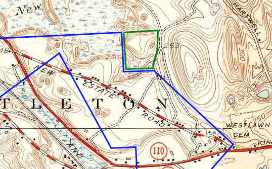
L-shaped Northeast Section with Dudley Mortgage
Deed fitted in
In 1723 Littleton, most of the roads we know today did
not exist, and many of the roads used then do not exist now. This
particular road is the old road blazed from Chelmsford to Groton around 1714
4, and is the "Highway"
referred to in the deed into Dudley when he bought the property in 1717 from the
Littleton Proprietors, and it is the "Old Way" referred to in the 1722
Dudley-to-Hammond deed, and it is the "Highway" referred to in the 1723
mortgage.
It was so tortuous that a new road was proposed in
1717 to avoid the looping of the old one. This new road is the "Proposed
Highway" in the 1717 Proprietors-to-Dudley deed, and it is the "Highway"
referred to in the 1722 Dudley-to-Hammond deed, and it is the "County Road"
referred to in the 1723 Dudley mortgage.
The point of this is that I have been able to
positively identify the course of the old road, all the way from Chelmsford to Groton
14, and with
this identified, there is only one place in the area potentially coved by the
Dudley-to-Hammond parcel that this 17.5 acre mortgage parcel can fit into. The location is
also naturally situated on a small plateau of land above the swampy meadows to
its south and west. On its west side, this little plateau is where the
Dudley-to-Hammond deed running eastward from the Northwesterly Corner bounds "up
upon the uplands." From there it turns and runs southerly, and thence
running easterly and making
the Northeasterly Corner, (and thus creating the L-shaped "notch"), and running southeasterly
from there. The area of this small plateau is approximately 18 acres.
With the 17.5 acre mortgage parcel fitted exactly on
the ground, and the northeastern L-shape notch of the Dudley-to-Hammond deed fitted into it,
then the declination of the northern (and northeastern) boundary
lines are exactly determined. This places the northern boundary side of
the parcel well to the north of Rattlesnake Hill, which results in the
ambiguously running property line
("...Southwesterly on the side of the hill called Rattlesnake Hill ...") as
being on the northern side of the hill.
With this resolved, the entire parcel falls into a
very accurate placement on the ground - far more accurately then could have
initially been expected.
Parker to Dudley Deed
The other Rattlesnake Hill deed is quite simple to put
on the ground as it is bounded to the north by the hill and to the west by the
Littleton town line. The southeast of the parcel, rather then being a
corner, has the corner cut off and is a line. This southeast line butts up
against the old road to Harvard which was in existence well prior to 1722.
The Littleton line that this abuts is the old line which was about 60
east of the current line.
Unlike in the Dudley-to-Hammond deed, in this instance
I have not fit the parcel to align exactly with the magnetic north of 1722.
This is because the parcel orientation is defined in the deed by the lay of
Littleton line (which is a few degrees east of south), as well as the
southwesterly lay of Rattlesnake hill, and the southwesterly line of the old
road to Harvard. Descriptive words used in the deed such as "southerly"
and "easterly" are terms meant to convey property lines running in those general
directions, as apposed to lines running in exact due south or due east
declinations. (See more on this below in the "Note on Antique Deed Descriptions"
section.)
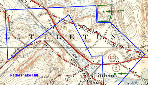
Rattlesnake Hill ~
Parker-to-Dudley Deed ~
1939 USGS Map
Red line indicates 1722 Littleton town Line
Placing the Parker-to-Dudley parcel on the ground, and
with the way it fits exactly into the contours and bounds and roads, again
clearly identifies Rattlesnake Hill as today's Oak Hill. The lay of the
old Littleton-Harvard town line is still visible today, just north of
Rattlesnake Hill, in a mile and a half section of stonewall which which runs
about 6 degrees east of the present town lines.
Note: this parcel is a mile and a quarter southwest
along Rattlesnake Hill from the Dudley-to-Hammond parcel and along an early road
that connected the two.
Dudley Witchcraft
A historical side note is that in 1720 Samuel Dudley's
wife, Abigail Dudley, was accused of witchcraft by the three young girls of the
Blanchard family. This was the last accusation of witchcraft to occur in
New England, and Mrs. Dudley died in childbirth before any formal accusations
were actually lodged. The eldest girl, who was the originator of the accusations
and 11 years old at the time, confessed in 1728 to Revered Turell in Medford
that it had all been sheer fabrication. For more information on this
incident, see
Ceremonial Time: Fact or Fiction? by Daniel V. Boudillion.
2 Possible Dudley Homestead Locations in 1720
Witchcraft Incident
There are two possible homestead locations for the
Dudleys at this time. Town tradition places the location at Beaver Brook (at Mill
Pond 4) just north of
Reedy Meadow on a 100 acre wedge of land that Dudley bought in 1717 from the
Littleton Proprietors. When this was sold to Hammond in 1722 the deed
records buildings as part of the transaction. However, the 17.5 acre
parcel that Dudley mortgaged in 1723 and withheld from the 1722
Dudley-to-Hammond transaction also references buildings. Both locations
were part of the original 100 acre Rattlesnake Hill area tract purchased from
the Proprietors in 1717. The exact Beaver Brook location is but a memory
now, and the 17.5 acre location is lost in the woods near the faint route of a long abandoned
cart-road.
A Note on Antique Deed Descriptions
Overall, and given enough work, these parcels fit
neatly with both the deed and landmark descriptions. In most instances the exact
corner locations and exact distances of individual property line lengths can be
at this time only close approximations, but the overall reconstructions are
remarkably accurate taken as a whole.
Also, the actual bounds and property
lines would not have been as wonderfully straight, and the corners would not
have been such exact right angles and 450
angles as drawn on the maps. The directions would not have been as exactly
cardinal-direction compass-oriented as the plots drawn on the maps suggest.
The actual property bounds at the time
were physical markers such as a "pine tree marked" or "a stake and a heap of stones."
The compass bearings in the deeds were meant to point towards these locations,
but in and of themselves are not exact due east or due south lines, for example.
Such deed descriptions at the time as "southerly" or
"northwesterly" were only meant to convey lines running generally in
those directions. Unless actual compass bearings were recorded, or the
bearings were recorded as "due east" for example, these were only meant to be
guides and pointers to physical markers, and not markers in and of themselves.
Therefore there are going to be
variations between what was intended and conveyed on the ground and how how it
appears today as laid out on a modern topographical map using deed descriptions
in a perfect literal sense. The perfect lines on the map would have in
reality wandered and wavered, would have not matched or run along exact cardinal
compass points, and would not have made perfect corners.
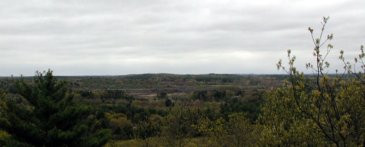
View Southeast from Rattlesnake Hill to Newtown Hill
click to enlarge
Also, many of the markers at that time are long gone.
The blazed trees of 1722 are obviously gone, and the heaps of stones are often
gone now as well. Many of these were removed as part of field clearing
after successive ownerships conglomerated and/or cut up parcels to the extent that
many of these old stone heap property markers simply ceased to mark property.
In some instances where the heap of stones remained as
a valid waypoint or corner, these heaps would have been incorporated into a
stonewall running the same line or making the same corner. A farmer making
walls as part of field clearing would have defined his property with them, and
thus many stonewalls which postdate the deeds mark these old property lines.
Some notes about these deed plots: The
Littleton of 1716 & 1722 was a very different place then it is today.
As mentioned previously, very few of today's roads existed then, and what few did often took
very different courses then they do now. Also, many of the original roads
referenced in the deeds no longer exist. Such is the case of the Old Way
referenced in the Dudley-to-Hammond deed. This Old Way was a tortuous
route carved through the woods from Chelmsford [Westford] to Groton [Ayer], a
section of which was superseded between 1717 and 1722 by the portion of
King Street running between Hartwell Avenue and Kimball Street.
4
Also, Mill Pond was not in existence in the 1720's.
Rather, it was created around 1750 by damming Beaver Brook to power the Warren's
Grist Mill.
7 Thus,
the Reedy Meadow Plain location as identified by
Margaret Drury's notes
7,
is only accurate for dates after 1750. In times prior to this, Reedy
Meadow Plain would have extended all the way across the southwest arm of Mill Pond and
north on either side of Taylor Street up to where Taylor crosses Beaver Brook.
It is only by keeping these changes in mind, and
viewing Littleton topography as it was in 1720, that these two deeds can be
accurately placed on the ground.
|
About
Magnetic Variation
It is an established fact that Magnetic North is
several degrees different then True Celestial North as determined by the star
Polaris, and that magnetic north is not a stable point. Over the years it has
been creeping northwardly, with a slight westward list, from its first located position at Canada's King
William's Island in 1831, to north of Bathurst Island in the Canadian Arctic
Icepack in 2001. It appears generally to be headed toward Siberia.
10a
As the magnetic north pole creeps slowly northward and a tad west this changes the number of degrees - called
magnetic variation - between Magnetic North and True (celestial) North.
Therefore a compass reading taken today will show a different magnetic north
then it would have 100 years ago. For example, in Littleton in 1900 the
variation between Magnetic North and True North was 12.462 degrees. In
2000 that variation had increased to 15.579 degrees. This represents a 3.1
degree migration westward of Magnetic North from True North in 100 years at this
location.
10b
In regards to old deeds this means that a compass
bearing from 1800 will not point in the exact same direction as a compass
bearing taken today from the same location. This means that the compass
bearings given in the 1722 Dudley-to-Hammond deed such as northerly and
southwesterly are significantly different today from an accuracy standpoint.
This can throw off plotting vintage parcels by hundreds of feet and yards over
long distances.
To most accurately plot the Dudley-to-Hammond deed
requires an accurate magnetic variation number for 1722. To the best of my
knowledge this is not available so it was required to recreate an approximation for
this date.
Fortunately the 1830 Hoar & Foster Plan of Littleton
survey map gives magnetic datum for town lines of that year.
11 The compass bearing of the section of Littleton-Harvard line running southerly
from approximately a half mile south of Pingeryville to approximately Beaver Brook is given as
"S6½E," which means the line runs
southerly 6.5 degrees east of south. I compared this line with the 1988 USGS
Ayer Quadrangle topographical map. On the 1988 map, this bearing is now
13½ degrees east of south due to the creep of the magnetic north pole.
This means that there has been a 70 variation
in the 158 years between 1830 and 1988. This number results in a .04430
average per year magnetic creep. (Bearing in mind that the actual magnetic
creep is not a steady yearly amount, and that magnetic north has been creeping
far swifter in recent years than in the 1800's when it was first located and
tracked.)
By calculating backwards this results in a 4.780
variation for the 108 years between 1722 and 1830. Thus the grand total of
magnetic creep between 1722 and 1988 is 11.750.
The magnetic variation for the 1988 USGS Ayer Quadrangle is a Magnetic North that is 15.50,
west of True North, so this results in Littleton in 1722 of a Magnetic North
being 3.750 west of True North.
Thus I laid out the Dudley-to-Hammond deed on the 1988
USGS Ayer Quadrangle topographical map using a datum line of 3.750
west of True as the magnetic north line of the 1722 deed. Having
established its orientation and position on this map and plotted the deed, I
transferred the plot to the 1939 USGS Ayer Quadrangle topographical map. I
chose to present the Dudley-to-Hammond on the 1939 USGS map because it is less
cluttered then the 1988 USGS map and more accurate then the 1893 USGS map.
A final note on magnetic variation:
Magnetic variation is based on the slow creep of the magnetic north pole, and
on local influences such as iron ore deposits etc. Thus "magnetic
variation" varies from location to location. For example, the variation
for the Ayer USGS Quadrangle in 1988 (which has the western half of Littleton on
it) is 15.50 west of True which results in a
3.750 magnetic variation for north in 1722 at
that location. The Billerica USGS Quadrangle in 1987 (which
has the eastern half of Littleton on it) is 160
west of True which results in a 4.250 magnetic variation for north in
1722 at that location.
Also, these calculations going back beyond 1830 are
extrapolations, and all variations calculated before 1900 are based on an
average, whereas it is known that the variation is not a steady yearly amount.
Therefore the final magnetic variation figure for 1722 is an approximation,
probably accurate only within a degree or two.
|
Why Did the Name Change?
A final question left to
answer is why or how the name changed from Rattlesnake Hill to Oak Hill - the
hill also going for a period of time unnamed on maps of the era.
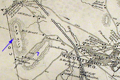
Two Oak Hills
The 1875 Beers Atlas map locates Oak
Hill in Littleton as being the now unnamed hill bounded to the east by Bruce
Road, to the South by Harvard Road, and in the North by Route 2A. The 1893
USGS Groton Quadrangle topographical map also marks this as Oak Hill. The
rare 1936 Fort Devons map of all the stonewalls in its vicinity also marks this
as Oak Hill. None of these three maps give a name to the hill in Littleton
we currently know as Oak Hill.
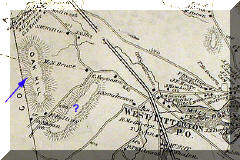
1875 Beers Littleton Atlas Map 1893 Groton USGS Map
(Town Line in Red)
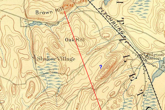
But with the issuing 1939 USGS Ayer
Quadrangle topographical map, the hill we today know as Oak Hill was labeled as
such. The current issue 1988 USGS topographical maps also keep to the new
designation. With this 1939 change, the hill previously labeled Oak Hill on the 1875,
1893, and 1936 maps is now left blank and unnamed.
1939 Ayer
USGS Map 1988 Ayer
USGS Map
It would appear that the Oak Hill name jumped ship
from one hill in Littleton to its immediate neighbor. But I do not believe
this is the full story.
Note: Oddly enough, the 1830 Hoar & Foster
Plan of Littleton survey map does not show either of these Oak Hills.
This is odd because Oak/Rattlesnake Hill is the highest location in Littleton at
504 feet. The only hills in Littleton on the Hoar and Foster map are
Newtown Hill (443 feet), Nashoba Hill (426 feet), and the Long Pond Brothers
(360 feet).
The Harvard Connection
Today's Oak Hill is actually a long ridge beginning in
Littleton and running southwest through Harvard. Its highest elevation is
in Harvard at 630 feet, which is about two miles southwest of the Littleton
line.
Interestingly, the 1893 USGS Groton Quadrangle map labels this
Harvard part of the ridge as Oak Hill, but does not extends this designation
into Littleton.
Harvard section is Oak Hill, Littleton section
has no name
(ridge is outlined in green
~ red
line is Littleton/Harvard line)
1893 USGS Map
Also, when the school district set-ups were first
being debated in Harvard town meetings in 1734, this northwest ridge section of
Harvard was known as the Oak Hill district of town.
5
(There was also a Bare Hill, Still River, Old Mill and Shabikin district.
5)
Thus the southern Harvard section of the ridge had the Oak
Hill name, and the northern Littleton section of the ridge had the Rattlesnake Hill name.
These two names were in contemporary use: Littleton was using the Rattlesnake
Hill name in 1722
6, and
Harvard was using the Oak Hill name by 1734.
5
It would appear from the 1875 & 1893 maps which give
no name for the Littleton section of the ridge that the Rattlesnake Hill name
had fallen out of general use. It also appears that no new name had been
generally adopted for this part of the ridge, at least from the 1875 & 1893
surveyors standpoint. Such a large hill - at 504 feet the largest hill in Littleton - would have been named on these maps had there been a name in
general use to label it with.
It would appear that the early Harvard use of the name
Oak Hill for their section of the ridge, and the naming of that part of the
Harvard Township the Oak Hill section, had creeped over the line into Littleton
and over time filled the void left by the non-use of the of the Rattlesnake Hill
name.
It is interesting to note that the names of all known
rattlesnake-named places in Littleton fell out of use over time. These
being: Rattlesnake Hill, Little Rattlesnake Meadow, and Snake Road.
Perhaps with the snakes gone the importance for such names warning of the
presence of rattlesnakes vanished as well.
Rattlesnake Hill ~
Littleton Massachusetts
However this may be, the name Rattlesnake Hill appears
to have fallen out of use after the extermination of the rattler in the early
19th century. The hill then seems to have gone without a generally agreed
upon name for a number of years including the period between 1875 and 1893.
By 1939 it had become known as we know it today: Oak Hill.
It would also appear that the general adoption of the
Harvard Oak Hill name for the Littleton portion of the ridge caused confusion
with the Oak Hill already adjacent northwesterly of the Littleton section of
the ridge. This adoption of the Oak Hill name on the Littleton portion of the
ridge would have forced out of use the name Oak Hill for the adjacent hill -
either through confusion or necessity. Thus today that hill is no longer
named on maps.
That significant landmarks such as hills can change
names over time is not unusual. Another example from Littleton is a hill
variously known as: Brown's Hill
4,
Bruce Hill
4, and Pingery
Hill. This is one of the most significant hills in Littleton due to the
fact that it is the Northwest Corner of the Township, and has been so from the
initial layout of the Nashoba Indian Plantation in 1654.
4 It is the only
original corner still in effect.
By the time of the incorporation of Littleton in 1714
it was known as Brown's Hill. In the 1890's H. J. Harwood refers to it as
Bruce's Hill, which like Bruce Street, is named after the Bruce family that
lived near there. Today it is know as Pingery Hill after the Pingery
family of Pingeryville, which was what this section of Littleton became known as
by the 1900's.
Conclusions
The Oak Hill of today's
Littleton's was the Rattlesnake Hill of Colonial times.
Appendix
Thanks to Gary Boston
for pulling all the deeds and deciphering them, without which this report would
not be possible; and thanks to the Littleton Historical
Society for their time and courtesy in responding to my many questions.
Sources
1. George A. Sanderson: Littleton Land Marks in Proprietors' Deeds:
Proceedings of the Littleton Historical Society (1896)
2. Belle Choate: Private Correspondence (2005)
3. George J. Burns: Historical Sketch of Ayer:
History of Middlesex County, Massachusetts, with Biographical Sketches of
many of its Pioneers and Prominent Men, Volume II, Chapter XLIV, D Hamilton Hurd
editor. (1890)
4.
Herbert Joseph Harwood: Historical Sketch of Littleton: History of Middlesex
County, Massachusetts, with Biographical sketches of many of its Pioneer &
Prominent Men, Volume II, Chapter LXXXVI, D. Hamilton Hurd editor.
(1890)
5.
Robert C. Anderson:
Directions of a Town: A History of Harvard Massachusetts (1976)
6.
Deed: Samuel
Dudley to Nathaniel Hammond, 3 July 1722, Middlesex Registry
Book 24, Page 6 & 7
7. Notes of the Littleton Historical Society.
8. Henry S. Nourse: History of the Town of Harvard Massachusetts 1732-1893
(1894)
9. Private Correspondence, source
withheld (2003)
10a. Natural Resources Canada: Long Term
Movement of the Pole
http://www.geolab.nrcan.gc.ca/geomag/long_mvt_nmp_e.shtml
10b. National Geophysical Data Center: Magnetic Field
Value Calculator
http://www.ngdc.noaa.gov/seg/geomag/magfield.shtml
11. Hoar & Foster: Plan of Littleton,
1830, Littleton Historical Society
12. Field work by Daniel V. Boudillion (2002)
13. Daniel Gookin: Historical Collection of the
Indians in New England (1674)
14. Daniel V. Boudillion: Finding Littleton's
Lost Chelmsford to Groton Road
(unpublished article, copyright
2005)
15. topozone:
www.topozone.com
16. Map: Town of Ayer,
1875, Atlas of Middlesex County F. W. Beers
The Deeds
Deed
from John Parker Jr. to Samuel Dudley, 6 February 1722
Middlesex Registry
Book 22, Page 319
"To all people before
whom ____ ____ shall come greetings know you that I John Parker Junior of
Littleton in the County of Middlesex … paid by Samuel Dudley of Littleton
aforesaid yeoman … bargained granted … and sold freely and absolutely unto the
said Samuel Dudley his heirs … a certain tract of upland land and meadow lying
in the Westerly part of Littleton aforesaid bounded as follows: beginning at a
Pine Tree marked on the Southerly side of Rattlesnake Hill then running
Southerly to a White Oak Tree marked then running Southwesterly to a White Oak
marked and running to a stake with a heap of stones [or possibly:
"to a ____ with ____ on it and"] running Westerly to Littleton Line then running
Northerly on Littleton Line to Walnut Tree marked and running Easterly to the
first mentioned Pine Tree which land and meadow contains by estimation Forty
Acres be the same more or less to have and to hold … in witness whereof I said
John Parker have hereunto set my hand and seal this Sixth day of February Anno
Domini 1722 … recorded and entered August Seventh 1723."
Deed from Samuel
Dudley to Nathaniel Hammond, 3 July 1722
Middlesex Registry
Book 24, Page 6 & 7
"To all Christian
people before whom this deed of sale shall come greetings know you that I Samuel
Dudley of Littleton in the County of Middlesex in his majesties province of the
Massachusetts Bay in New England yeoman for and in consideration of the sum of
seven hundred and thirty pounds in good payable money of the province aforesaid
paid to my content before signing by Nathaniel Hammond of which in the county
aforesaid in the province aforesaid yeoman the receipt whereof aforesaid Samuel
Dudley do hereby acknowledge therewith to be fully satisfied contented and paid
thereof and of every part and parcel thereof do absolutely acquit and discharge
the said Nathaniel Hammond his heirs administrators and assigns? forever have
therefore given granted bargained sold _____ offered conveyed and confirmed and
do absolutely sell convey and confirm to the said Nathaniel Hammond by his heirs
and assign forever a certain tenement tract or tracts of land of lands laying
and being in Littleton aforesaid bounded as follows
First or biggest
tract of lands with the buildings thereon containing by estimation Two Hundred
and Fifteen Acres be the same more or less beginning at a crotched pine tree
upon Reedy Meadow Plain localled? being the Southwesterly Corner then running
Northerly to a stake and heap of stones then crossing the Highway to a stake and
heap of stones then running Westerly to a stake and heap of stones then running
a little Northwesterly to a black oak tree then running over the Old Way to a
walnut tree then running Southwesterly on the side of the hill called
Rattlesnake Hill to a black oak tree marked so running on the side of the hill
to a stake and heap of stones being the Southwesterly Corner on the side of the
hill then running Northerly to a stake and heap of stones being the
Northwesterly Corner then running Easterly by Thomas Powers land and running to
a white oak tree by William Barrett's meadow bounding on Barrett's and Deacon
Joseph Warren's meadow(s) running to a stake and heap of stones then crossing
the meadow to a stake and heap of stones then bounding upon the upland running
Southerly to a white oak tree then turning Easterly to a pine tree marked being
the Northeasterly Corner then running southeasterly by a pine tree running to a
stake and heap of stones being the Southeasterly Corner then running
Southwesterly to a stake and heap of stones bounding upon Eleazer Lawrence's
meadow crossing the brook called Beaver Brook to a stake and heap of stones then
running to the first mentioned corner or crotched tree it being upland meadows
lowland? area?
Also Fifteen Acres
more [or less] being by meadow and woodland in Littleton aforesaid lying between
Thomas Power's land and John Perham's land bounding on or near the way that
leads from said Powers to John Perham's.
Also Fifty Acres of
upland and swamp and meadow land lying at the upper end of Long Pond Swamp so
called bounded as follows viz beginning at a white oak tree marked being the
Northwesterly Corner then running Southerly to a white oak tree marked being the
Southwesterly Corner of Samuel Barrits(?) lot then running Easterly in the swamp
till it makes up the said Fifty Acres.
Also Six Acres of
meadow more or less in Littleton aforesaid? lying on Beaver Brook joining on
Jonathan Whitcomb’s meadow to a stake and heap of stones running Westerly
bounding on the uplands to a birch tree being the Northwesterly Corner then
running Southerly to a stake at the said Brook then running Easterly bounding on
said Brook to a stake then running Northerly to the first mentioned corner
To have and to hold
the above ____ ____ as the same are butted and bounded ____ ____ to be bounded
with all buildings? fencings? and all their ____ growing or lying on the same or
in any wise belonging to the said Nathan Hammond his heirs ____ ____ ____
forever with the rights profits privileges thereon? so belonging to his? and
their only sole proper use benefits and ___ and ____ said Samuel Dudley … heirs
and ____ do covenant to with ____ said Nathaniel Hammond his heirs … that all
the … of this bargain and sale and until … Samuel Dudley on the ___ sale and
proper ownership of the ____ and have good right full power and lawful authority
to sell convey and … to the said Nathaniel Hammond his heirs and ___ forever and
that said Nathaniel Hammond shall by virtue of the ___ have hold … enjoy the ___
as fully as I ever did or might have done without the … malefactions trouble or
contradictions of me the said Samuel Dudley my heirs or assigns? or any other
person or persons whomsoever laying any lawful claim therein hereby do promise
to warrant? ____ and I? ____ the above grantee? ____ from all ____ malefactions
trouble or contradictions of any person whomsoever … perform any other act that
shall be needful for the performing? this Judgment … that so the premises may
abide a good perfect ____ to the said Nathaniel Hammond and his heirs and
assigns? forever in witness thereof I have set my hand and seal with the
consent? of Lydia Dudley my wife we have both … the Third day of July 1722 and
in the eight year of his Majesties Reign. Samuel Dudley and Seal. Lydia
Dudley and seal. Signed sealed and delivered in presence of ____
Stephen Harris and Joseph Becker. Samuel Dudley appearing before me the
subscriber? owned this Judgment to be his proper ____ July 4 1722 ____ Middlesex
Cambridge June 20 1724 ____ ____ ____ ____ ____."
Mortgage of
Property from Samuel Dudley to Com Mass, 13 February 1723
Middlesex Registry
Book 24, Page 457 & 458
"…or parcels of land
____ ____ and being in the township of Littleton aforesaid ____ of upland and
meadow land vis one parcel of land chiefly upland and containing One Hundred and
Fifty Acres and is butted and bounded as follows vis beginning at the
Southwesterly Corner at a black oak tree marked so running Northerly
to another oak tree marked so running Northerly to another white oak tree
marked and then running Easterly to a small white oak tree marked and
running Southerly to a white oak tree marked then running Easterly
by land of Mr. Robert Cummings to a white oak tree marked and then running
Southerly to a stake and heap of stones and from thence to the first
mentioned black oak
Also another piece of
land containing Seventeen Acres and a Half bounded as follows Southerly
and Westerly by land of Mr. Nathaniel Hammond Northerly by land of
Josiah Buttrick Easterly by a Highway that ____ from Josiah Buttrick to
the County Road
Also Thirty? Three
Acres and a Half of meadow lying on Beaver Brook so called ____ said brook
Northerly and Easterly on land of the said Samuel Dudley and
Southerly on meadow of the said Samuel Dudley or however otherwise the same
is now butted or bounded or ____ to be bounded together with ____ and singular?
the houses out houses buildings barns stables yards gardens edifices fences ways
____ ____ …"
Email Daniel V.
Boudillion
Back to Field
Journal
Copyright © 2005 by Daniel V. Boudillion
|