The longevity of Harvard
Shaker Community was remarkable. In the 1880s, the average lifespan of a
Harvard Shaker was just over seventy years of age. It would be another 50
years before the general populace were to equal that. A casual walk through
the Harvard Shaker cemetery reveals an unusual number of long lived community
members, and ages in the 90s are not uncommon.
The Harvard Shakers
were in no doubt as to the reason of their extraordinary health and
longevity. They had a special spring from which the entire community
drank exclusively. In fact, they claimed a 16% increase in lifespan from
its waters alone.
In 1855 a drought
threatened the Harvard Community with failed wells. Not far from the East
Family village was a spring on the west side of Oak Hill. Water from the
spring was piped via a buried aqueduct for an entire mile to a reservoir on a
hill behind Church Family, the main Shaker village. From here, all the
houses of the Church Family community were supplied with its waters which were soon
discovered to be of unusual purity. The entire cost of the new aqueduct
system was $5000.
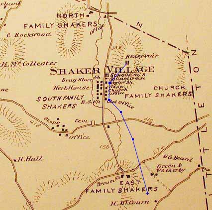
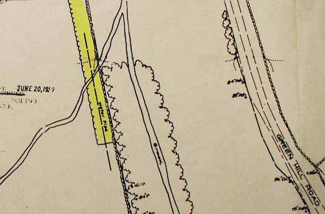
1875 Map of Harvard Shaker Village -
Aqueduct in Blue
The spring water was
tested and found to have lower turbidity, and a higher chemical purity,
than even that of the much renowned Poland Springs water:
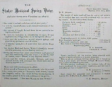
Purity Analysis in Shaker Water
Advertisement
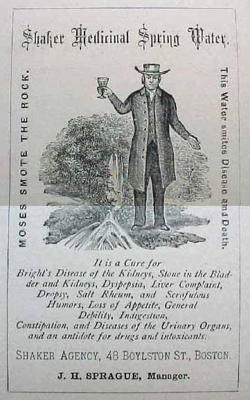
Harvard Community Elder
Elijah Myrick saw the business opportunity in this, and procuring a
testimonial from the Massachusetts assayer, proceeded to bottle and sell
the waters for many years as a Shaker commodity. The bottled
water was sold as Elijah Myricks Shaker Spring Water and proudly
advertised as follows:
|
|
Shaker
Medicinal Spring
Water
Moses Smote the Rock.
This Water smites Disease and Death.
It is a Cure for Bright's Disease of the
Kidneys, Stone in the Bladder and Kidneys, Dyspepsia, Liver Complaint,
Dropsy, Salt Rheum, and Scrofulous Humors, Loss of Appetite, General
Debility, Indigestion, Constipation, and Diseases of the Urinary Organs,
and an antidote for drugs and intoxicants.
|
Another
original sign advertising the spring water is on display in the Shaker
building at Fruitlands Museum.
(The curator felt $50 was a reasonable charge for a
single digital photograph of it. I disagree, and so it is not
reproduced here.)
Today, much of the aqueduct has disappeared and most trace of its path
is lost. Route 2 has obliterated the East Family Shaker village.
With the help of Marc Sevigny and George Watkins, I
located the spring at about the 400 foot elevation on the west side of Oak
Hill, several hundred yards northeast of the site of the old East Family village.
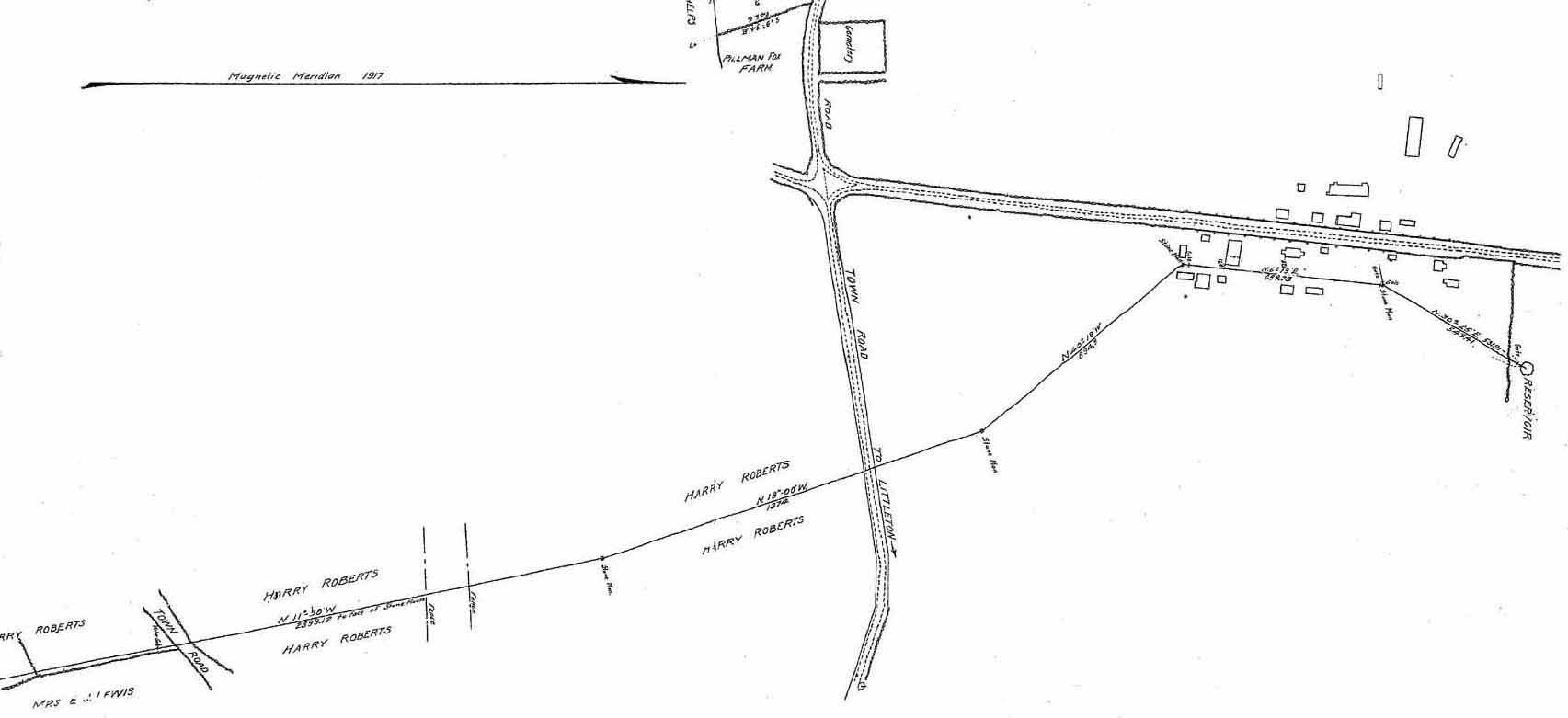
1917 Fiske Warren Survey Map including
Route of Aqueduct
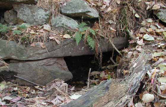
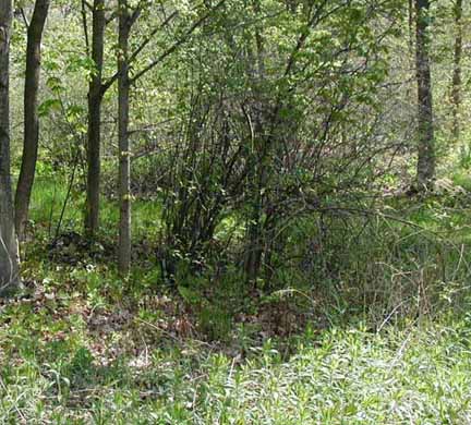
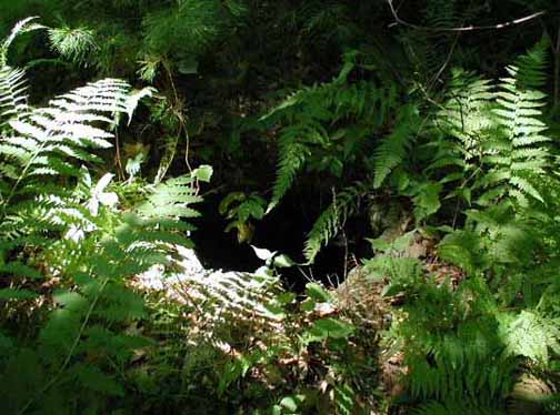
The spring is in a marshy area on a small wooded plateau. It is
enclosed within an unusual looking stone and mortar spring house, with a
locked iron door. From a distance, it had the initial appearance of
a large mossy boulder. The spring house is in good repair, having
been repaired (or it is rumored, reconstructed) in the 1970's by the
Harvard Conservation Commission. Prior to our October visit, we
had attempted to locate the key to the spring house, but to no avail.
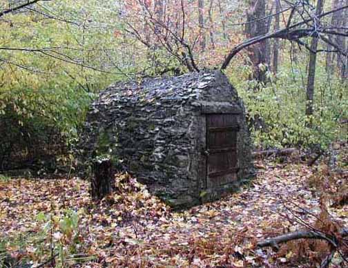
Shaker Spring House - Oak Hill
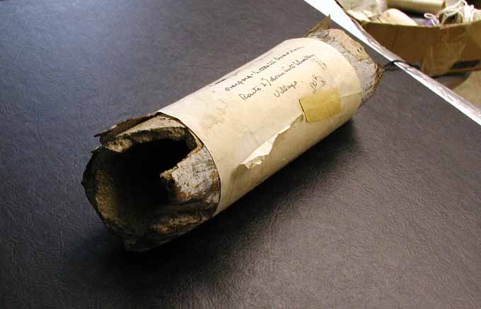
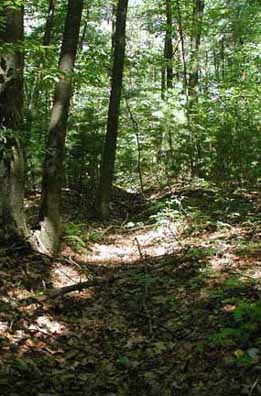
From the spring house, there was no discernable trace of the aqueduct or
its route. There did not appear to to be any run-off, and I wondered
if the spring was still flowing. However, in following the
best conjectured path of the aqueduct, we were rewarded with finding a
broken end of the piping spilling water into a small vernal pool.
The piping was about 3" outside diameter and cement lined, which tallied with Shaker records.
It was pleasing to find the spring waters still had a good rate of flow.
I noticed too, several minnows darting in and out of the broken pipe.
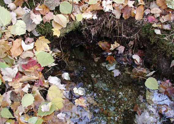
Broken Aqueduct Pipe - Spring Water Still
Flowing
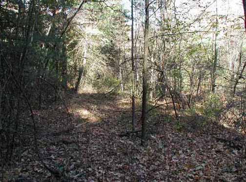
We followed the assumed path of the aqueduct several hundred feet from the
break down to where Route 2 cut across its path. There was nothing,
however, to indicate its presence beyond the broken pipe end. I tied
a marker to a tree at the edge of Route 2 to indicate where it probably
would have crossed.
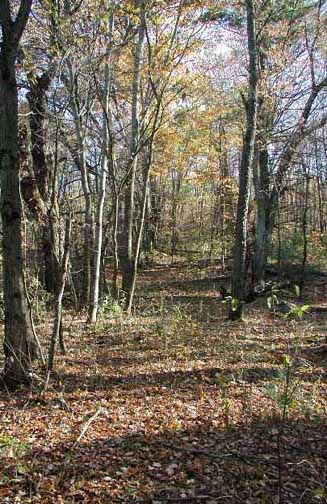
Two weeks later I investigated the far side of Route 2 for any indication
of the aqueduct. As luck would have it, directly across from where
the marker was tied, was the aqueduct cutting across a marsh in a long
berm. The berm was about four to six feet high, and had a stone culvert
to allow ground water to pass beneath it. This in itself proves that
the berm is not an unrelated dam, but is the actual path of the pipeline.
Survey maps from the Route 2 construction also mark this berm as the
pipeline. The far end of the berm has a long trench running down its
center indicating the piping had been dug out of that section.
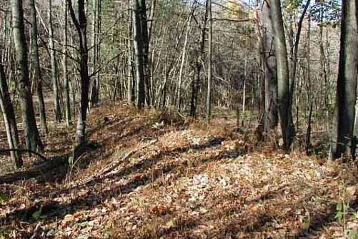
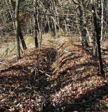
Aqueduct Berm & Aqueduct Berm showing
where pipeline was removed
Culvert Under Aqueduct Berm & 1958 Survey
Map of Berm
From here, the aqueduct plunged under the old route of Littleton Road, and
then under Littleton Road proper. About 50 feet east down the old
route of Littleton Road, a second abandoned road branched off to the right,
to be intersected (and obliviated) by Route 2. This is actually the
lower portion of Green Hill Road, this section of which was abandoned when Rte 2 bisected it in
the late 1950's. It was by means of this road that the Shakers had access
to the the spring house.
Old route of Littleton Road & old route
of Green Hill Road
An old concrete highway marker with "WCH"
engraved on it may be found on the west side of the abandoned section of
Green Hill Road. I take the engraving to mean:
"Worcester County Highway", but I may not be correct.
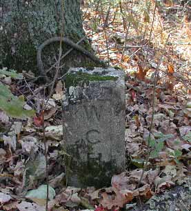
Highway Marker - Green Hill Road
I investigated the far side of Littleton Road, but this currently has
several houses on it, and I found no indication of the aqueduct's path.
I spoke with the owner of the property through which it most likely
passed, but he had no knowledge of it.
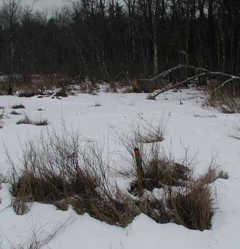
According to Shaker records, the aqueduct, once passing Littleton Road,
traversed a large marsh and swamp. The records note that each turn
of the aqueduct was marked by an engraved slate marker, noted on old survey
maps as a "stone monument." There were four such monuments placed,
two in the Village, and two in the swamp either side of Sheehan Road.
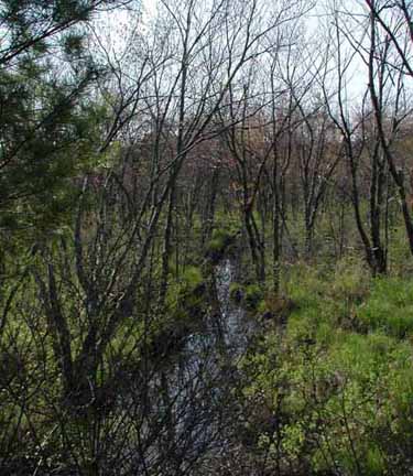
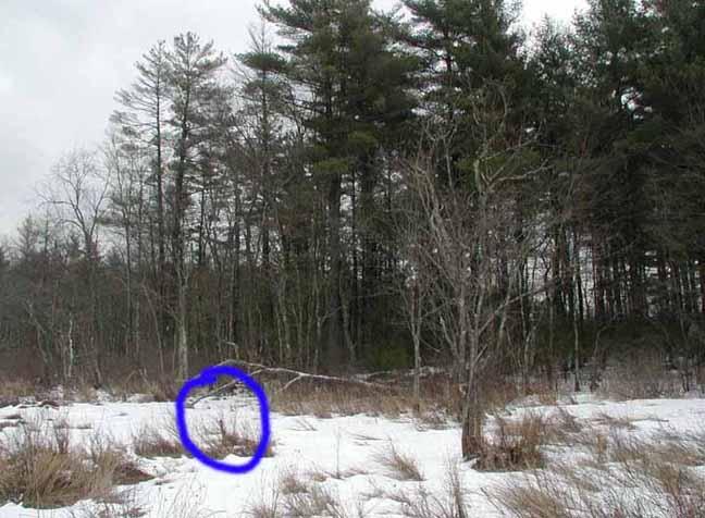
Path of buried Aqueduct at Sheehan Road
The monuments in the Village have since disappeared. The monument
north of Sheehan Road was found by Mr. Bayard Underwood of
The
Shakerton Foundation Inc., who owns that parcel of land.
The monument to the south of the road is still in its original location
deep in the swamp. It is the only one of the four monuments left
standing, no doubt due to its inaccessibility. Its location may be seen from
aerial photos at the right angle corner of a brook the Shakers
straightened when they were farming the area. It is not possible to
access this area due to the increased water-table. Removal of this
or any such
marker is a criminal offence under Massachusetts General Laws Chapter 266,
Section 94
& Section 95.
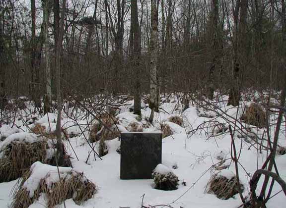
Slate Marker in Swamp
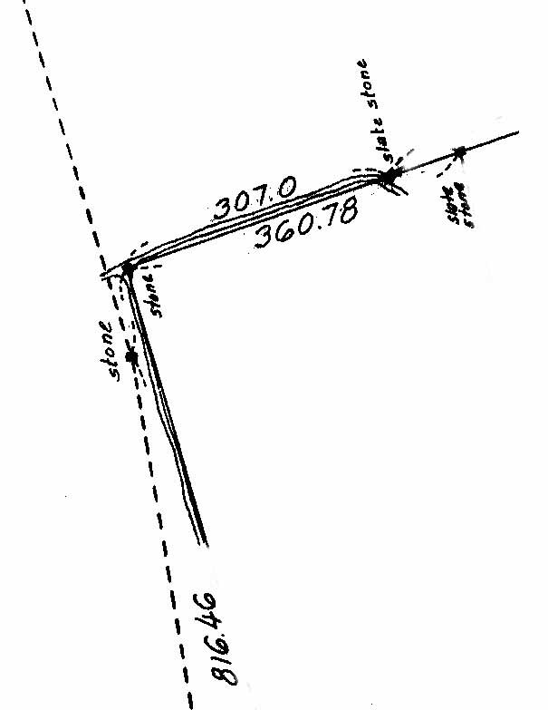
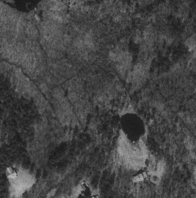
Location of Slate Marker in Swamp &
Aerial View of Location
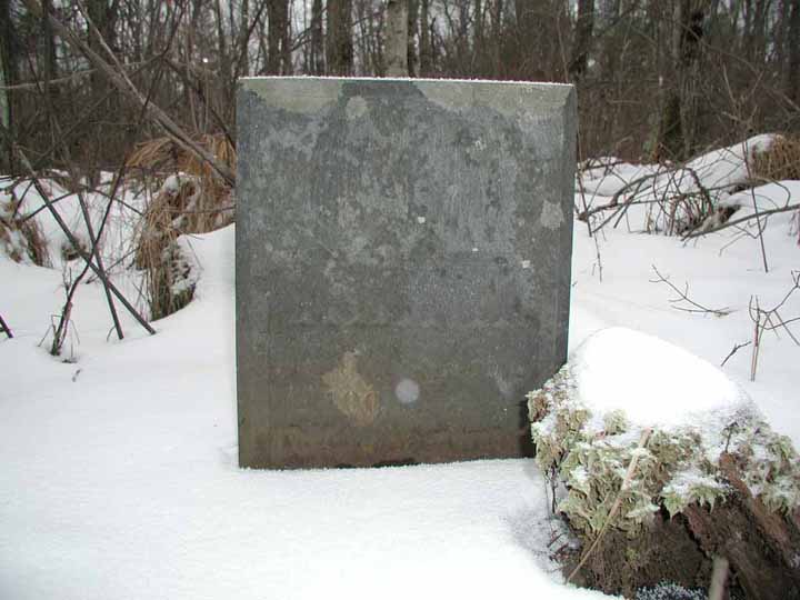
The full inscription of the swamp slate is
hidden by the current level of the water-table. It is probable
that the obscured section of the inscription reads similarly to the
formula of the Underwood slate.
The visible portion of the Swamp Slate is as follows:
|
To the Spring 2400 ft. →
To Second Angle ...
|
As for the other Sheehan Road monument, Mr.
Underwood has since removed it and marked its original location with a pipe. The
monument is now located as the centerpiece in the flower garden of his
residence in Groton Massachusetts.
Original and Current Location of the
Underwood Marker
(the
marker pipe is 10 feet
to the left
of the bush)
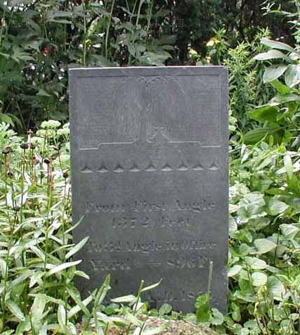
The stone monuments are quite interesting.
The Shakers, believing in the "waste not, want not" principle, used
rejected partially carved headstone slates. Mr. Underwood's slate is
decorated with the willow tree and urn carving at the top which was the
style of the time. Where the funerary inscription would be, the
Shakers carved location data. The Underwood slate is inscribed as
follows:
There is also supposed to be a sketch of one of
the makers in the published diary of a Harvard Shaker. I have not
been able to locate this sketch or confirm it's existence.
From the swamp the aqueduct ran to the "3rd
Angle" mentioned above, in what is now Mr. Erhart Muller's backyard.
At this location, as well as at the final Village marker to the north,
there was a gate valve. Both these markers and valves are long gone.
However, the buried pipeline of the aqueduct still remains. Mr.
Muller discovered this much to his surprise when he was having a pond dug
in his backyard - the backhoe ruptured the buried pipe, filling the pond
nicely.
Location of "Office" Valve and Marker
The pipe is of singular construction. It
is cement, half inch thick wall, with a 2 inch inside diameter.
The outside diameter of the pipe is wrapped in a sheath of iron sheeting,
riveted along the seam.
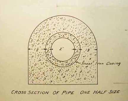
1917 Fiske Warren Survey Map of Pipe &
and Actual Section of Pipe
From the "Office Yard" the pipeline continued
below ground through the backyards of the houses on the east side of the street.
A final turn - complete with gate valve and slate marker (now missing) - was behind the
Taylor Shop.
From there it ran up the hill to its final destination. A second
pipe led from this marker point under the street to supply the other side
of the road with the special waters.
The gate valve locations not only regulated
water flow, but were also exterior water distribution points - spigots
where you could fill a pail. All the houses of the Church Family
community were said to be connected to this water supply. Gate valves
were located at the reservoir, the Taylor Shop, the Office, and where the
berm met old Littleton Road.
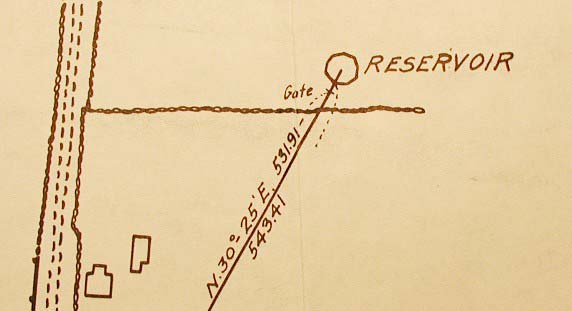
1917 Fiske Warren Survey Map showing
Reservoir shape
The aqueduct ended in a reservoir on the side of
a low hill at the north end of Church Family village. This reservoir
was actually a large cistern within an octagonal wooden structure.
By 1962 the structure was in serious dilapidation. The elderly lady
who owned the land was concerned with the hazard it posed to children
playing in the area, and had it filled in and bulldozed by a Mr. Sweeter.
There is presently nothing at the location to indicate that a structure or
a large cistern ever stood there. I have been unable to locate any
pictures or contemporary drawings of this unusually shaped octagonal
structure. The only references to its shape are via remembrances of
local residents and notations on the survey drawings made for Mr.
Fiske Warren who bought Church Family village
from the Harvard Shakers in 1918 for his Tahanto Enclave.
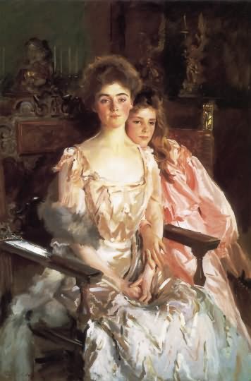
(Fiske Warren established a number of such
"enclaves" here and worldwide. These communities were based on
communal land ownership, but did not survive his death in 1938.
Click
here for a picture of Gretchen & Rachel Warren, his
wife and daughter.)
It is probable that the Shakers got the idea of
the aqueduct ready-made from an earlier (and cruder) water system they had
set up previously in their East Family Village. This spring and
aqueduct system is on the same side of the hill as the newer spring house,
and at approximately the same elevation, but several hundred yards further
west along the hillside. It consists of an uncapped stone well at a
natural spring, and a trough leading down from the well some distance to
the village.
East Family Spring & Path of Aqueduct
The trough is a six inch deep and two foot wide
depression that leads down from the well to the site of the East Family
village. I presume that piping of some sort, since removed, was laid
in the trough. Further details and pictures of this prototype water
system may be seen at
A Second Harvard Spring.
If anyone has further information
regarding the Springs and its history, I
would be pleased to hear from them. My email address is:
dvb@boudillion.com
Special thanks to Mark Magowan who repeatedly pulled old maps out of his hat.
Thanks to Bayard Underwood for letting me photograph the slate marker and
the pipe section in the Shakerton Foundation collection. Thanks as well to Marc Sevigny, George Watkins, Erhart Muller,
Jonathan Feist, and Gary Boston for
their assistance with this report.


